My newest hobby is exploring various apps. I’m fairly ruthless about it. I download them easily. If they don’t work, or provide something useful or interesting, they’re gone.
I found one on Sunday morning that was pretty neat. It is called DCTraffic. They have many like it for other areas. Basically, it’s a mash up of Google Maps with Public Cams and the iPhone itself.
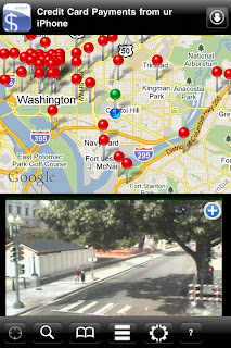
It provides a map of public "traffic" cams around the DC. You select a “pin” on the top, and it “snaps” a picture from that cam and presents it in the box below.
I suppose it is useful if you want to see if an intersection, ramp or highway is blocked. But, as a practical matter, we all know at Rush Hour means traffic can clear up or become problematic in a heartbeat. So, really, what is the point? By the time you get to a given location, local conditions will be different, and the only practical guidance relates to the time of day. (for which, you shouldn’t need an app.)
So with that said, the point of this little app, to me, seems to be to have some fun, and just marvel at the technology.
My wife and I found ourselves on what we call “An Epic Walk” in DC. At one point, we were within a block of one of the cams. (Ok, maybe that was by design). Using the map and the photo, we easily found where a cam was, and then “Snapped” our picture.
This image is a screen shot of what was on my iPhone the moment I hit the Red Pin above (turning it Green) snapping the picture in the bottom. That is my wife and I standing on the sidewalk looking at the camera.
It is amazing to think about how much information is out there, and how it is all coming together in ways we could hardly ever imagine. It is also a lot of fun figuring out what is possible, and to wonder what is gonna happen next!

